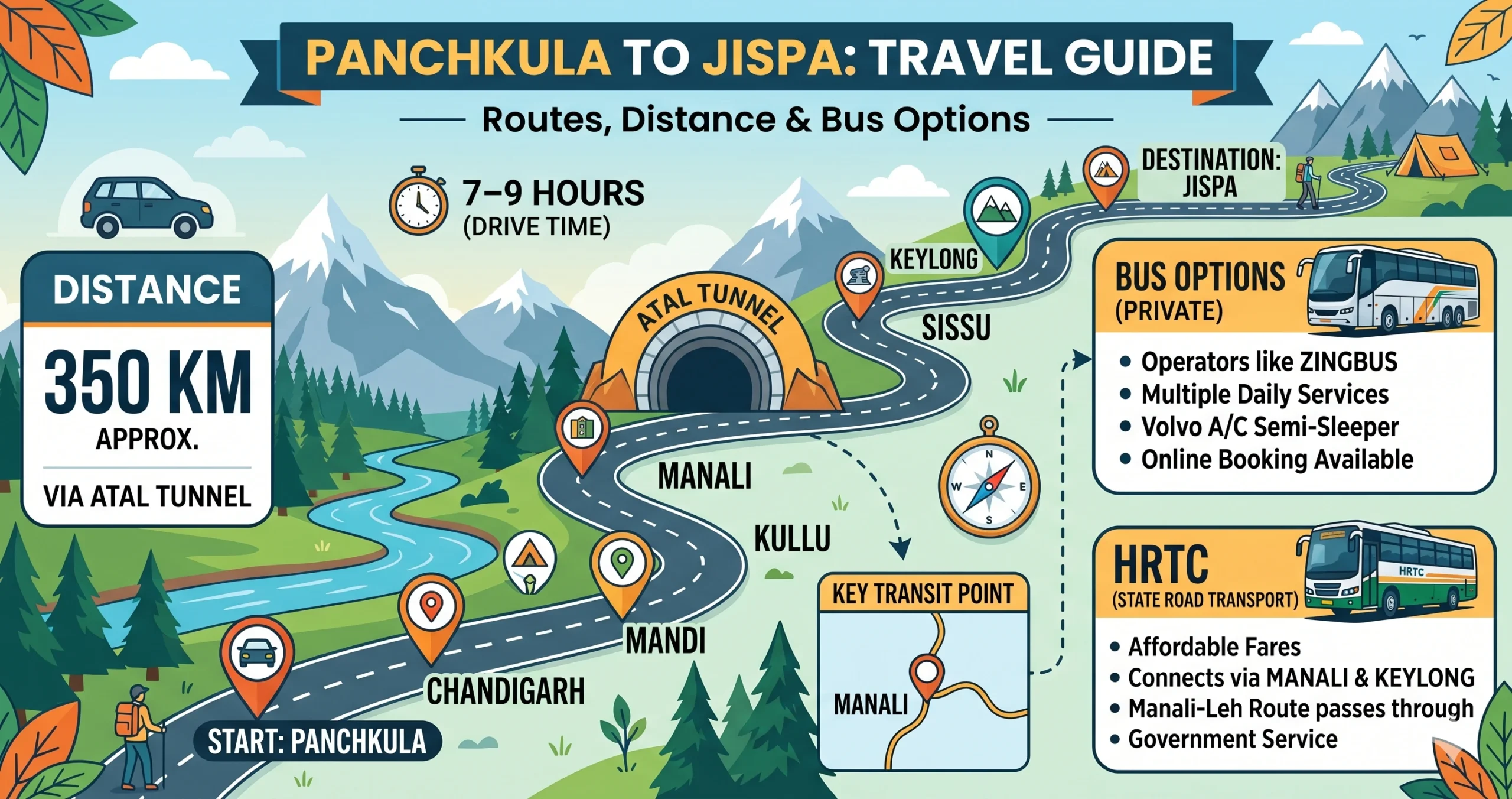
From smooth plains to rugged Himalayan terrain, the drive from Panchkula to Jispa is a proper trans-Himalayan adventure. Sitting along the Bhaga River on the legendary Manali–Leh Highway, Jispa is a quiet, high-altitude village known for striking scenery and peaceful riverside camps.
- Distance: ~370–385 km
- Travel time: 10–12 hours by car, 12–14 hours by bus
- Altitude: ~10,500 ft (3,200 m)
Since the Atal Tunnel opened, getting to Jispa has become noticeably faster and safer than it used to be.
Traveling by Road (Car/SUV)
Driving is the best way to experience the changing landscapes — from lush valleys to cold deserts.
Primary Route: Via Mandi & Atal Tunnel (Fastest Route)
Panchkula → Ropar → Kiratpur Sahib → Bilaspur → Sundernagar → Mandi → Kullu → Manali (bypass) → Atal Tunnel → Sissu → Keylong → Jispa
- Distance: ~375 km
- Time: 10–12 hours
- Good for: Speed, safety, and comfort
Panchkula to Mandi is a smooth four-lane highway. Mandi to Manali follows a scenic drive along the Beas River. The tunnel keeps the Manali-to-Keylong stretch smooth and reliable, and the final run from Keylong to Jispa is flat and scenic along the river.
Alternative Route: Via Rohtang Pass (Classic Adventure Route)
Panchkula → Mandi → Kullu → Manali → Rohtang Pass (13,050 ft) → Gramphu → Khoksar → Sissu → Keylong → Jispa
- Distance: ~390 km
- Time: 12–14 hours
- Good for: Scenic photography and a genuine sense of adventure
This road tops out at 13,050 feet, is only open from May to October, and requires a permit for the pass itself.
Comparing the Road Routes
| Route | Key Stops | Distance | Time | Verdict |
|---|---|---|---|---|
| Via Atal Tunnel (recommended) | Mandi → Kullu → Atal Tunnel → Keylong | ~375 km | 10–12 hrs | Safest, fastest, and gets you to Jispa before dark |
| Via Rohtang Pass | Manali → Rohtang Pass → Sissu → Keylong | ~390 km | 12–14 hrs | Epic views, but needs permits, patience, and real hill-driving skill |
Traveling by Bus (Budget & Practical)
Public transport relies heavily on Himachal Road Transport Corporation.
Option 1: Manali Volvo + Local Transport (Best Comfort)
- Leg 1: Chandigarh to Manali by overnight Volvo
- Leg 2: Manali to Jispa by HRTC bus or shared cab
- Time: 12–13 hours
- Cost: ₹1,000 – ₹1,800
Option 2: Direct HRTC to Keylong + Taxi
- Board from ISBT Sector 43
- Travel to Keylong
- Take a local ride to Jispa, 22 km further
- Time: 13–14 hours
- Cost: ₹850 – ₹1,000
Traveling by Train (Not Practical)
Jispa has no railway connection, and the nearest practical station is near Kiratpur Sahib — which still leaves a long road journey either way. Trains just aren’t a realistic option here.
Check Current Train Availability
Traveling by Air (Fastest but Expensive)
- Nearest airport: Bhuntar Airport
- Distance to Jispa: ~140 km
- Taxi time: 4.5–5 hours
Verdict: Saves time, but subject to weather delays.
Lining Up the Travel Modes
| Mode | Approach | Time | Cost (One Way) | Good For |
|---|---|---|---|---|
| Personal SUV | Via Mandi & Atal Tunnel | 10–12 hrs | ₹4,500 (fuel & tolls) | Travelers wanting to stop for photos along the Bhaga River |
| Bus (premium combo) | Volvo to Manali + local cab or bus | 12–13 hrs | Bus (₹1,000) + cab (₹500) | An overnight trip that gets you into the mountains feeling fresh |
| Direct state bus | HRTC from Chandigarh to Keylong + cab | 13–14 hrs | ₹850–₹1,000 | Solo travelers who’d rather avoid switching buses mid-trip |
| Private taxi | Direct from Panchkula | 10–12 hrs | ₹9,000–₹13,000 | Groups wanting a completely hands-off ride to their riverside camp |
Picking Your Season
- Spring (April–May): Melting snow and increasingly beautiful landscapes.
- Summer (June–August): Pleasant temperatures (10–22°C), and the best window for camping and road trips.
- Autumn (September–October): Clear skies, making this the best stretch for mountain photography.
- Winter (November–March): Heavy snowfall and sub-zero temperatures, with limited access but genuinely striking winter scenery.
Top Places to Visit Around Jispa
- Bhaga River — flows right beside Jispa, perfect for a quiet walk or some photography
- Gemur Monastery — a short drive away, with sweeping valley views
- Keylong — about 22 km off, the administrative hub of Lahaul and Spiti, good for stocking up before heading toward Leh
- Deepak Tal — a mirror-still high-altitude lake right on the Manali–Leh Highway
- Baralacha La — one of the highest passes on the highway, and the gateway to Ladakh
- Suraj Tal — a glacial lake near Baralacha La, among the highest in India
Most of these fit easily into a day trip, or as a stop on your way further toward Leh.
Places to Stay
Accommodation in Jispa ranges from simple to surprisingly comfortable:
- Riverside camps
- Hotels and guesthouses
- Homestays
- Seasonal luxury camps
Book well ahead if you’re traveling between June and September, and check in advance whether your stay offers parking, meals, reliable electricity, and any mobile coverage — these vary considerably across the valley.
Food Along the Highway and in the Village
A visit to Jispa is incomplete without experiencing the simple yet comforting cuisine of the Lahaul Valley. Most hotels, guesthouses, and campsites serve freshly prepared meals using locally available ingredients that are well suited to the mountain climate.
Popular dishes include steaming bowls of thukpa, vegetable and chicken momos, butter tea, Tibetan bread, noodle soups, rajma-chawal, and hearty North Indian meals. During colder months, warm soups, herbal teas, and freshly prepared local dishes become especially popular among travelers.
Several cafés and roadside eateries along the Manali–Leh Highway also offer hot parathas, Maggi, tea, coffee, and snacks, making them ideal stops during the journey. While dining options in Jispa are fewer than in Manali, the peaceful atmosphere and warm hospitality provide a memorable mountain dining experience.
Responsible Tourism in Lahaul Valley
The Lahaul Valley is a fragile high-altitude environment, and a few simple habits go a long way:
- Carry reusable water bottles and shopping bags.
- Avoid littering and dispose of waste responsibly.
- Respect local customs, monasteries, and religious sites.
- Stay on marked trails while hiking.
- Avoid disturbing wildlife and grazing animals.
- Support local cafés, homestays, and handicraft shops.
- Minimize the use of single-use plastics.
A Few Things to Remember
- Jispa sits at about 10,500 feet, so mild altitude sickness is possible
- An overnight stop in Manali helps your body adjust before continuing on
- Pack warm clothes even in summer, along with medicines, water, and offline maps
Why Jispa Is Worth the Detour
- Riverside camping right along the Bhaga
- A quieter, calmer alternative to busy Manali
- A natural stopover before continuing toward Leh or Baralacha La
FAQs: Panchkula to Jispa Travel Guide
1. What is the distance from Panchkula to Jispa?
The distance from Panchkula to Jispa is approximately 370 to 385 km, depending on the route.
2. How long does it take to reach Jispa from Panchkula?
It takes around 10 to 12 hours by car and 12 to 14 hours by bus, depending on traffic and weather conditions.
3. What is the best route from Panchkula to Jispa?
The best and fastest route is via Mandi → Kullu → Manali → Atal Tunnel → Keylong → Jispa along the Manali–Leh Highway.
4. Is the Atal Tunnel route better than Rohtang Pass?
Yes, the Atal Tunnel route is faster, safer, and open year-round, while the Rohtang Pass route is seasonal and requires permits.
5. Can I travel to Jispa via Rohtang Pass?
Yes, but only between May and October. The Rohtang Pass route offers stunning views but involves steep climbs and heavy traffic.
6. Are road conditions good from Panchkula to Jispa?
- Panchkula to Mandi: Excellent highway
- Mandi to Manali: Smooth scenic road
- Manali to Jispa: Well maintained via the Atal Tunnel
Overall, roads are good, but mountain driving experience is recommended.
7. Is it safe to drive to Jispa?
Yes, but you should:
- Avoid night driving
- Check weather conditions
- Be cautious on mountain roads
Driving becomes more challenging after Keylong.
8. Are buses available from Panchkula to Jispa?
There are no direct buses to Jispa. You can take a bus operated by Himachal Road Transport Corporation to Keylong or Manali, then continue by local transport.
9. What is the best bus route to reach Jispa?
The best option is:
- Chandigarh to Manali by Volvo
- Manali to Jispa by HRTC bus or shared taxi
10. What is the taxi fare from Panchkula to Jispa?
Taxi fares usually range between ₹9,000 and ₹13,000, depending on the vehicle and season.
11. Is there any train connectivity to Jispa?
No, Jispa is not connected by rail. The nearest access point is near Kiratpur Sahib, after which you must travel by road.
12. What is the nearest airport to Jispa?
The nearest airport is Bhuntar Airport, about 140 km away from Jispa.
13. What is the best time to visit Jispa?
- May to June: Pleasant weather
- September to October: Clear skies and the best views
- Winter: Extremely cold, with heavy snowfall
14. Do I need a permit to visit Jispa?
No permit is required for Indian travelers visiting Jispa. However, permits may be needed if you continue further toward Leh.
15. Is acclimatization required for Jispa?
Yes. Since Jispa is at high altitude (~10,500 ft), it is recommended to acclimatize, especially if traveling directly from the plains.
16. What should I pack for a Jispa trip?
Carry:
- Heavy woolens
- Sunscreen and sunglasses
- Medicines for altitude sickness
- Power bank and offline maps
Explore More Lahaul, Spiti & Himalayan Road Trip Guides
If you’re planning to continue beyond Jispa, explore our detailed travel guides on Panchkula to Keylong, Sissu to Chandigarh, Jispa to Chandigarh, and Chandigarh to Chandratal Lake. Adventure enthusiasts can also discover routes to Manali and Kaza, along with Baralacha La, Tabo, and the wider Spiti Valley, for an unforgettable trans-Himalayan experience. These guides cover road conditions, altitude considerations, accommodation options, fuel availability, acclimatization tips, and essential travel advice to help you enjoy a safe and memorable mountain journey.