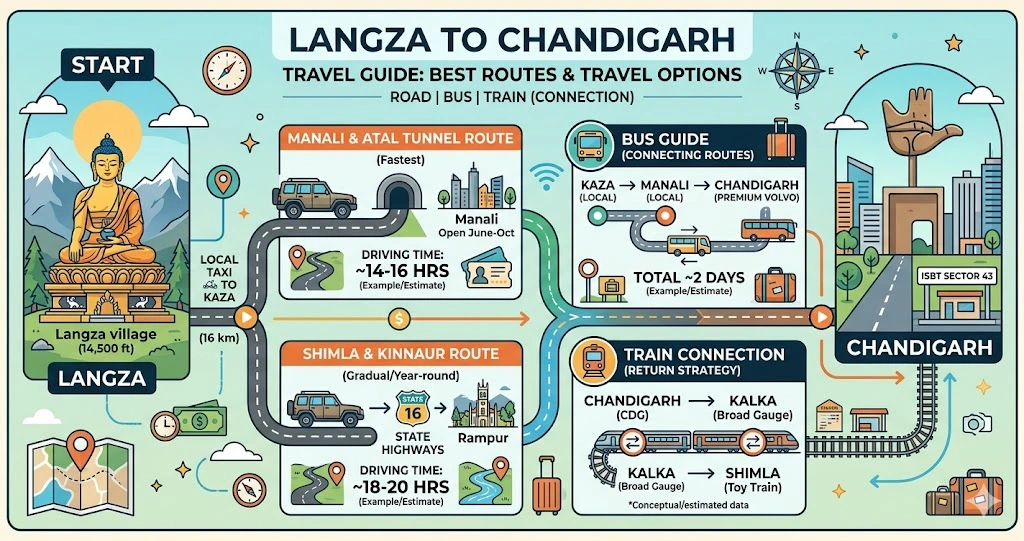
Driving from the towering golden Buddha and high-altitude marine fossil beds of Langza (perched at 14,500 feet in the Spiti Valley) down to the bustling, organized grid of Chandigarh is a massive trans-Himalayan descent. You will leave the cold desert ridges, cross high mountain passes, and navigate the lush river valleys of Himachal Pradesh before hitting the plains of Punjab and Haryana.
This guide explains both major routes, realistic travel times, public transport options, costs, fuel stops, and safety tips — everything you need to plan the descent properly.
Quick Overview
| Detail | Information |
|---|---|
| Distance | 470–540 km (depending on route) |
| Driving time | 16–22 hours |
| Minimum days needed | 2 (3 recommended) |
| Recommended vehicle | High ground-clearance SUV |
| Best season | June to October (Manali route) |
Key takeaway: This is not a single-day journey. Plan at least one overnight stop, ideally in Manali or Reckong Peo, and give yourself buffer time for weather and road delays.
Traveling by Road (Car/SUV)
Driving is the most practical and immersive way to complete this expedition. A high ground-clearance SUV is strongly recommended.
Route A: Via Kunzum Pass and Manali (Fastest, Summer Only)
Path: Langza → Kaza → Losar → Kunzum Pass → Batal → Chhatru → Gramphu → Atal Tunnel → Manali → Kullu → Bhuntar → Mandi → Bilaspur → Kiratpur Sahib → Chandigarh
- Distance: ~470 km
- Time: 16–18 hours of driving, split across 2 days
- Open: Roughly mid-June to mid-October, weather permitting
This is the quickest way out of Spiti, but also the roughest. The stretch between Kaza and Batal involves broken dirt tracks and multiple water crossings fed by melting glaciers. Locals call these streams “pagal nallahs” (mad streams) because they swell dangerously in the afternoon as the day’s snowmelt peaks — always cross them in the morning.
Once you exit the Atal Tunnel near Manali, the road transforms completely. From Manali to Chandigarh, you’re on smooth four-lane highway for most of the way.
Who should choose this route: Confident mountain drivers with an SUV who want the adventure and the shortest overall distance. An overnight halt in Manali is strongly recommended.
Route B: Via Kinnaur and Shimla (All-Weather Option)
Path: Langza → Kaza → Tabo → Nako → Reckong Peo → Karcham → Rampur → Shimla → Solan → Kalka → Chandigarh
- Distance: ~540 km
- Time: 20–22 hours, split across 2–3 days
- Open: Most of the year, including winter
This route follows the Spiti and Sutlej rivers down through Kinnaur. It’s longer, and the cliff-hugging roads near Karcham demand attention, but the surface is far better maintained than the Batal stretch, and it stays open when Kunzum Pass is buried under snow.
The bonus: you pass through Tabo (home to a 1,000-year-old monastery), Nako’s lake village, and the apple country of Kinnaur — arguably the more scenic descent.
Who should choose this route: Anyone traveling between November and May, first-time Himalayan drivers, or travelers who prefer safer roads over saved hours.
Route Comparison at a Glance
| Route | Distance | Time | Season | Best For |
|---|---|---|---|---|
| A: Via Manali | ~470 km | 16–18 hrs | Jun–Oct only | Speed, adventure driving |
| B: Via Kinnaur | ~540 km | 20–22 hrs | Year-round | Safety, winter travel, scenery |
Traveling by Bus: The Kaza Hub Strategy
Langza has no direct bus connectivity, so every public-transport journey starts with reaching Kaza, the administrative hub of Spiti.
- Langza to Kaza by taxi — about 45 minutes, ₹800–₹1,200.
- Kaza to Manali or Shimla by HRTC bus — the Manali route takes 10–12 hours in season; the Shimla route via Kinnaur is typically a two-day journey with a night halt in Reckong Peo.
- Manali/Shimla to Chandigarh by Volvo — comfortable AC coaches take 6–8 hours and run frequently.
Total budget: roughly ₹2,000–₹3,500 per person. It’s the cheapest way down, though physically tiring — expect long days on winding roads.
Flying or Taking the Train
Neither option gets you all the way, but both can shorten the final leg:
- By air: The nearest airport is Kullu–Manali Airport at Bhuntar. If you can reach Manali by road, a short flight covers the Bhuntar–Chandigarh leg in about 45 minutes. Flights here are weather-dependent and often pricey, so keep a road backup plan.
- By rail: If you descend via Shimla, you can ride the heritage narrow-gauge toy train from Shimla to Kalka — a UNESCO-listed experience — and connect onward to Chandigarh by train or taxi.
For most travelers, road remains the primary and most reliable mode; treat air and rail as scenic or time-saving supplements.
Cost Comparison by Travel Style
| Mode | Approach | Duration | Approx. Cost | Suits |
|---|---|---|---|---|
| Self-drive SUV | Manali or Kinnaur route | 2+ days | ₹6,000+ in fuel | Experienced adventure drivers |
| HRTC + Volvo combo | Taxi → HRTC → Volvo | 2–3 days | ₹2,000–₹3,500 | Budget backpackers |
| Private cab from Kaza | Local driver to Manali/Chandigarh | 2+ days | ₹15,000+ | Comfort seekers, families |
Best Time to Make This Journey
- June to September: The prime window. Kunzum Pass is open, weather is pleasant, and both routes are usable. Ideal for the Manali route.
- October: Crisp air, golden light, thinner crowds — superb for photography. Lean toward the Kinnaur route late in the month, as Kunzum Pass can close without much warning.
- November to May: The Manali route shuts down under heavy snow. Travel only via Kinnaur–Shimla, and check road advisories before setting out, as even this route can face temporary closures after snowfall or landslides.
Fuel Planning (Don’t Skip This)
Fuel stations are scarce in Spiti, so plan every fill-up:
- Kaza: The last reliable pump in the valley — top up here no matter which route you take.
- Manali: Multiple stations once you’re through the Atal Tunnel.
- Reckong Peo and Rampur: Your refueling points on the Kinnaur route.
If your vehicle’s range is tight, carry a small reserve can, especially on the Manali route where the Kaza–Manali stretch has no pumps at all.
High-Altitude Safety Tips
Langza sits well above 14,000 feet, so altitude matters as much as road condition:
- Spend a day or two in Kaza acclimatizing before beginning the descent.
- Stay hydrated and avoid alcohol during the high-altitude portion.
- Watch for symptoms of acute mountain sickness (headache, nausea, dizziness) and descend if they worsen.
- Use engine braking on long downhill sections instead of riding the brakes — overheated brakes are a real hazard here.
- Start driving early each morning to avoid afternoon stream surges and to reach your halt before dark.
Connectivity in Spiti
Mobile coverage is patchy. BSNL works most reliably across Spiti; Jio and Airtel are limited to Kaza and larger towns. Download offline maps before you leave Langza, and don’t count on internet in the remote villages.
Food Worth Stopping For
Part of the joy of this route is eating your way down the mountains. In Spiti, warm up with thukpa, thenthuk, momos, tingmo, butter tea, and locally made yak cheese. Once you reach the Kullu and lower Himachal stretch, look for traditional Himachali dishes like siddu (steamed stuffed bread), madra, and babru at roadside dhabas.
Travel Responsibly
Langza’s fossil beds are ancient and protected — admire them, photograph them, but never collect or buy fossils. Respect monastery customs, carry your trash out of the valley, use reusable bottles, and choose homestays and local cafés where you can. Stick to designated roads; off-roading damages fragile high-altitude terrain.
Emergency Contacts
| Service | Number |
|---|---|
| Police | 112 |
| Ambulance | 108 |
| Fire | 101 |
| HRTC enquiry | 1100 |
| Nearest hospital | Civil Hospital, Kaza |
Final Word
The drive from Langza to Chandigarh is less a transfer and more an expedition — a 14,000-foot descent through two of Himachal’s most spectacular valleys. Pick the Manali route if the season allows and you crave rough-road adventure; pick Kinnaur if you value safety, views, and year-round reliability; pick the bus combo if you’re watching your budget. Whichever you choose, start early, fuel up in Kaza, and give the mountains the time they demand.
Frequently Asked Questions
1. Where is Langza located?
Langza is a high-altitude village in the Spiti Valley of Himachal Pradesh, situated at around 14,500 feet, famous for its ancient fossils and the giant Buddha statue overlooking the valley.
2. What is the distance from Langza to Chandigarh?
The distance ranges between 470 km to 540 km, depending on whether you take the Manali route or the Kinnaur route.
3. How long does it take to travel from Langza to Chandigarh?
The journey takes approximately 16 to 22 hours of driving time, but it must be split over 2 to 3 days due to terrain and fatigue.
4. What is the best route from Langza to Chandigarh?
- Fastest route: Via Kunzum Pass to Manali (summer only)
- All-weather route: Via Kinnaur to Shimla
5. Is the Langza to Manali route open all year?
No, the route via Kunzum Pass remains open only from mid-June to mid-October due to heavy snowfall in winter.
6. Can I travel directly by bus from Langza to Chandigarh?
No direct buses are available. You must first reach Kaza and then take buses to Manali or Shimla, followed by a Volvo to Chandigarh.
7. What is the cheapest way to travel from Langza to Chandigarh?
The cheapest option is:
- Taxi from Langza to Kaza
- HRTC bus to Manali or Shimla
- Volvo bus to Chandigarh
Total cost: ₹2,000 – ₹3,500
8. Is it safe to drive from Langza to Chandigarh?
Yes, but only if:
- You are experienced in mountain driving
- You use a high ground-clearance vehicle (SUV)
- You avoid night driving in Spiti
9. Which is better: Manali route or Kinnaur route?
- Manali route: Faster but rough and seasonal
- Kinnaur route: Longer but safer and open most of the year
10. Are there fuel stations available on this route?
Fuel stations are limited. Key locations include:
- Kaza (limited supply)
- Manali
- Reckong Peo (Kinnaur route)
Always carry extra fuel if possible.
11. Can I complete the Langza to Chandigarh journey in one day?
No, it is not recommended due to long distance, rough terrain, and driver fatigue. Plan at least 1–2 overnight stops.
12. Is there any train connectivity from Langza?
Langza has no railway station. The nearest rail access is via:
- Kalka (via the Shimla route)
- Chandigarh Railway Station
13. Are flights available for this route?
There are no direct flights. The nearest airport is Kullu–Manali Airport, and flights there are weather-dependent and expensive.
14. What is the best time to travel from Langza to Chandigarh?
- Best season: June to October (for the Manali route)
- Winter travel: Only via the Kinnaur route
15. What are “pagal nallahs” and are they dangerous?
“Pagal nallahs” are glacial water streams that cross roads, especially between Kaza and Manali. They can be dangerous in the afternoon due to strong water flow — cross early in the day.
16. Do I need permits to travel from Langza to Chandigarh?
Indian citizens generally do not need permits. However, check the latest rules if traveling near border areas in Spiti.
Explore More Himachal & Spiti Travel Guides
If you’re planning to explore beyond Langza, don’t miss our detailed guides on Panchkula to Langza, Delhi to Kaza, Kaza to Manali, Chandigarh to Chandratal Lake, Manali to Chandigarh, and Shimla to Chandigarh. Whether you’re searching for the fastest route, best overnight stops, road conditions, or transport options, our destination guides will help you plan a safer and more enjoyable Himalayan adventure.
Disclaimer: Distances, travel times, road conditions, transport schedules, and seasonal openings (particularly Kunzum Pass) are approximate and change frequently due to weather, landslides, and government advisories. Always verify current road status with local authorities or HPTDC before departure.