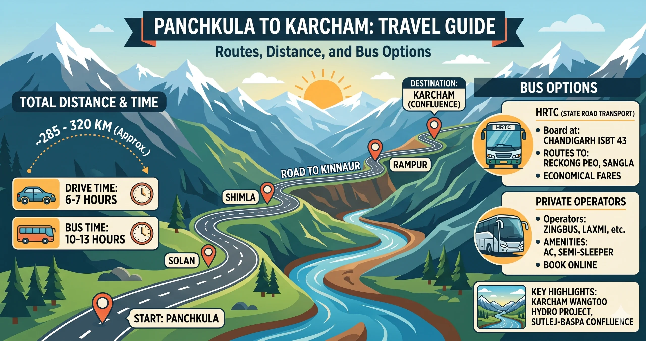
Traveling from Panchkula to Karcham is more than a road trip — it’s a shift from the urban plains into raw, rugged Himalayan terrain. Sitting where the Sutlej and Baspa rivers meet, Karcham works as the gateway to both Sangla Valley (and Chitkul beyond it) and the Reckong Peo–Spiti route.
- Distance: ~285–310 km
- Travel time: 9–11 hours by car, 12–14 hours by bus
- Terrain: Mountain highways, ghat roads, and cliff-cut sections
Traveling Along the Hindustan-Tibet Highway
Driving is the most immersive way to take in this journey, especially given how legendary this highway is.
The Main Road: Via Shimla and Narkanda
Panchkula → Solan → Shimla (bypass) → Theog → Narkanda → Rampur Bushahr → Jeori → Wangtoo → Karcham
- Distance: ~285 km
- Time: 9 – 10.5 hours
- Good for: Scenery combined with the fastest overall time
Panchkula to Shimla is a smooth highway drive. Shimla to Narkanda climbs through forest up to about 8,800 feet. From Narkanda, the road drops dramatically into the Sutlej valley over rugged, cliff-cut stretches.
The Winter Alternative: Via Basantpur and Kingal
Panchkula → Shimla → Dhalli → Naldehra → Basantpur → Kingal → Rampur → Karcham
- Distance: ~310 km
- Time: 10 – 11.5 hours
- Good for: Reliable travel when snow closes the main road
Since this road sits at a lower altitude, it stays open even when heavy snowfall blocks the Narkanda stretch.
Comparing the Narkanda and Basantpur Roads
| Route | Key Stops | Distance | Time | Verdict |
|---|---|---|---|---|
| Via Narkanda (recommended) | Shimla → Narkanda → Rampur → Jeori | ~285 km | 9–10.5 hrs | Fastest and most scenic |
| Via Basantpur (winter backup) | Naldehra → Basantpur → Kingal → Rampur | ~310 km | 10–11.5 hrs | The reliable choice during snowfall |
Traveling by Bus (HRTC Network)
Public transport here is dependable, thanks to Himachal Road Transport Corporation.
Direct bus (the budget pick)
- Board at ISBT Sector 43
- Route: Chandigarh to Reckong Peo, passing through Karcham
- Fare: ₹700–₹950
- Time: 12.5 to 14 hours
- Ask the conductor to drop you at Karcham bridge
The Shimla break journey (a bit more comfort)
- Volvo: Chandigarh to Shimla
- Local bus or taxi: Shimla to Karcham
- Time: 13 to 15 hours
- Cost: About ₹1,000
Seats can be booked through the HRTC portal or platforms such as RedBus and AbhiBus.
Traveling by Train (Toy Train Experience)
Though Karcham has no rail connectivity, you can enjoy the iconic Kalka–Shimla Railway along the way.
- Drive to Kalka
- Take the toy train to Shimla, about 5.5 hours
- Continue by road, another 7–8 hours
This suits travelers chasing a scenic, unhurried journey rather than speed.
Traveling by Air
- Nearest airport: Shimla Airport (Jubbarhatti)
- Still requires a 7–8 hour drive afterward
Verdict: Avoid flights; road travel is essential here.
Travel Options Compared
| Mode | Approach | Time | Cost (One Way) | Good For |
|---|---|---|---|---|
| Personal SUV/car | Via NH5 & Narkanda | 9–10.5 hrs | ₹3,500 (fuel) | Travelers with the stamina for continuous mountain driving |
| Private taxi | Direct from the Tricity | 9.5–11 hrs | ₹7,500–₹10,000 | Groups wanting a hands-off ride without the fatigue |
| Direct state bus | HRTC to Reckong Peo from Sector 43 | 12.5–14 hrs | ₹700–₹950 | Budget travelers heading deep into the Himalayas |
| Bus (comfort combo) | Volvo to Shimla + HRTC to Karcham | 13–15 hrs | ~₹1,000 | Solo travelers wanting a more comfortable plains-to-Shimla leg |
Best Places to Visit Near Karcham
Karcham’s central location makes it an excellent base for exploring the beautiful landscapes of Kinnaur. Within a short drive, travelers can discover charming villages, apple orchards, monasteries, and spectacular Himalayan viewpoints.
- Sangla Valley — one of Himachal’s most picturesque valleys, with traditional wooden houses and apple orchards
- Chitkul — the last inhabited village near the Indo-Tibet border, with pristine riverside views
- Reckong Peo — Kinnaur’s district headquarters, with bustling markets and views of the Kinner Kailash range
- Kalpa — known for sunrise views over Kinner Kailash and its traditional temples
- Roghi Village — a quiet spot overlooking deep valleys, popular with photographers
- Karcham Wangtoo viewpoints — roadside spots looking over one of India’s major hydroelectric projects
Somewhere to Sleep
Look for hotels in Sangla, homestays in Chitkul, guesthouses in Reckong Peo, and seasonal riverside camps if you’d rather sleep closer to the water. Budget lodges are also easy to find throughout the area.
Eating Your Way Through Kinnaur
Karcham itself has limited dining, but nearby Sangla, Reckong Peo, and Kalpa all offer restaurants and cafés serving Himachali and Tibetan-inspired food. Look out for siddu (a steamed wheat bread served with ghee or lentils), thukpa, momos, rajma-chawal, and chana madra. In colder months, warm soups and herbal teas are especially popular.
Kinnaur’s apple orchards also produce some of Himachal’s best apples — during harvest season, look for fresh fruit, homemade jams, and locally made dry fruits. Most homestays serve simple, home-style meals made with fresh local ingredients.
Packing for the Journey
Worth carrying:
- Warm layered clothing
- Waterproof jacket
- Trekking shoes
- Sunglasses
- Sunscreen
- Personal medicines
- Offline maps
- Power bank
- Cash, since ATMs are limited beyond Rampur
- Vehicle documents
- Torch or headlamp
- Snacks and drinking water
Traveling With Care in Kinnaur
Kinnaur’s villages and orchards are close-knit and easily disrupted, so a few habits go a long way:
- Respect local customs and traditions.
- Keep rivers and mountain trails free of litter.
- Avoid damaging apple orchards or private property.
- Support local homestays, cafés, and handicraft businesses.
- Minimize the use of single-use plastics.
- Stay on designated roads and trekking paths.
- Drive carefully to reduce dust and noise in villages.
Worth Keeping in Mind
- Karcham sits near a sensitive zone due to the Karcham Wangtoo Hydroelectric Project, so expect ID checks at the bridge
- Roads beyond Rampur Bushahr get narrow and can be landslide-prone
- Start early, around 5–6 AM, for safer daylight driving
What’s Next From Karcham?
Once you reach Karcham, you have two directions to choose from:
- Right turn: toward Sangla Valley and Chitkul
- Straight on: toward Reckong Peo and Spiti Valley
Common Questions About This Trip
1. What is the distance from Panchkula to Karcham?
The distance from Panchkula to Karcham is approximately 285 to 310 km, depending on the route you choose.
2. How long does it take to reach Karcham from Panchkula?
It takes around 9 to 11 hours by car and 12 to 14 hours by bus, depending on traffic, weather, and road conditions in the Kinnaur region.
3. What is the best route from Panchkula to Karcham?
The best route is via Shimla → Narkanda → Rampur → Jeori → Wangtoo → Karcham along the Hindustan-Tibet Highway, offering the fastest and most scenic drive.
4. Is there an alternative route to avoid snow near Narkanda?
Yes. During heavy snowfall near Narkanda, you can take the Basantpur–Kingal route via Naldehra, which stays open due to its lower altitude.
5. Are the road conditions good from Panchkula to Karcham?
- Panchkula to Shimla: Excellent highway
- Shimla to Narkanda: Good hill road
- Rampur to Karcham: Narrow, rough, and cliff-cut roads
Drive cautiously, especially beyond Rampur Bushahr.
6. Is it safe to drive to Karcham?
Yes, but it requires careful driving. Roads in Kinnaur are narrow with steep drops. Avoid night driving and check weather conditions before starting your journey.
7. Are buses available from Panchkula to Karcham?
There are no direct buses to Karcham, but you can take a Himachal Road Transport Corporation bus from Chandigarh to Reckong Peo or Sangla, which passes through Karcham.
8. Where can I board a bus for Karcham?
You can board buses from ISBT Sector 43, which is the nearest major bus terminal to Panchkula.
9. What is the taxi fare from Panchkula to Karcham?
Taxi fares typically range from ₹7,500 to ₹10,000, depending on the vehicle type and season.
10. Is there any train connectivity to Karcham?
No, Karcham has no railway station. The nearest rail access is via the Kalka–Shimla Railway, after which you must continue by road.
11. What is the nearest airport to Karcham?
The nearest airport is Shimla Airport (Jubbarhatti), but it is not very useful, as you still need a long road journey afterward.
12. Why is Karcham important for travelers?
Karcham is a key junction where the road splits toward Sangla Valley (the Chitkul side) and Reckong Peo (the Spiti route).
13. What is the best time to visit Karcham?
- April to June: Pleasant weather
- September to October: Clear mountain views
- Winter (December–February): Snowfall, but riskier travel
14. Do I need a permit to visit Karcham?
Indian travelers do not need a permit for Karcham. However, permits are required further ahead near Jangi for restricted areas close to the Indo-Tibet border.
15. What should I carry for this road trip?
Carry:
- Valid ID proof
- Warm clothes, even in summer
- Snacks and water
- Vehicle documents
- Offline maps, since network coverage is weak in Kinnaur
Explore More Himalayan Travel Guides
- Panchkula to Shimla
- Panchkula to Manali
- Panchkula to Jispa
- Panchkula to Keylong
- Panchkula to Mashobra
- Karcham to Chandigarh
Travel Information Disclaimer
The travel information in this guide is provided for general reference only. Road distances, travel times, fares, bus schedules, permits, weather conditions, and road status can change without notice due to traffic, construction, landslides, snowfall, government restrictions, or operator updates.
Mountain routes in Himachal Pradesh can be unpredictable, especially in Kinnaur and higher-altitude areas. Always verify current conditions, transport availability, accommodation, and permit requirements before starting your journey.
Travelers should exercise caution, start early, drive only if experienced with hill roads, and avoid night travel where possible. The publisher is not responsible for delays, losses, accidents, missed connections, or any inconvenience arising from the use of this information.
For the safest trip, confirm details with local transport operators, official road advisories, and trusted live map navigation before departure.