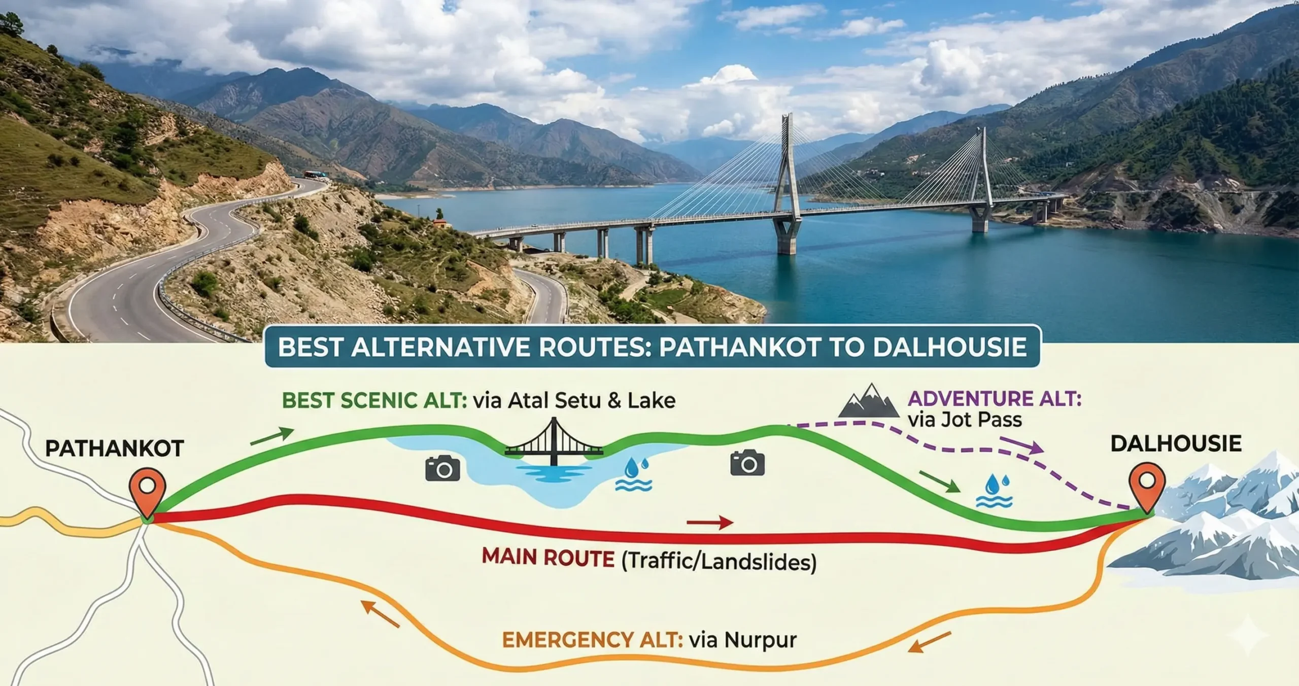
The main road from Pathankot to Dalhousie, via Dunera on NH 154A, is the fastest option under normal conditions — but it’s also prone to traffic jams, army convoy movement, and monsoon landslides. That’s enough of a hassle that a lot of travelers end up looking for a smoother, less crowded alternative instead.
After comparing road conditions, travel time, safety, and scenic value, the best alternative route from Pathankot to Dalhousie for most travelers is the Shahpur Kandi – Ranjit Sagar Dam – Atal Setu route.
Distance and Travel Time
| Detail | Information |
|---|---|
| Starting point | Pathankot, Punjab |
| Destination | Dalhousie, Himachal Pradesh |
| Main route distance | ~82 km |
| Main route travel time | Fastest under normal conditions |
| Alternative routes | Add roughly 20–45 minutes for the Dam or Nurpur routes, or up to 1.5 hours for the more difficult Jot Pass route |
The Scenic Dam Route: Most Recommended
This route is widely considered the best overall alternative because it balances comfort, safety, and scenery.
Route overview
Pathankot → Jugial → Shahpur Kandi → Ranjit Sagar Dam → Atal Setu → Dunera → Banikhet → Dalhousie
- Distance: Around 92 km
- Extra time: 20–30 minutes more than the main route
- Road condition: Mostly good, with a few isolated patches near the dam
Why this route stands out
- Drives alongside the scenic Ranjit Sagar Dam reservoir
- Extremely low traffic compared to NH 154A
- Features the iconic Atal Setu cable-stayed bridge
- Peaceful and ideal for tourists and families
Best for: Scenic drive, relaxed travel, photography, weekend tourists
The Nurpur–Lahru Bypass: The Emergency Route
When landslides block the Dunera stretch, this route becomes the safest alternative route from Pathankot to Dalhousie.
Route overview
Pathankot → Nurpur → Sadwan → Lahru → Tunnu Hatti → Banikhet → Dalhousie
- Distance: About 100 km
- Extra time: 40–45 minutes
- Road condition: Excellent till Nurpur, narrow but paved afterward
Why choose this route
- Used by traffic police during road closures
- Wider highways till Nurpur
- Less risk of landslides compared to Dunera side
Best for: Monsoon travel, night driving, first-time hill drivers
The Jot Pass Adventure: For Expert Drivers
This is not the easiest, but definitely the most adventurous alternative.
Route overview
The Route: Pathankot → Nurpur → Chowari → Jot Pass → Khajjiar → Dalhousie
Why take this route
- Passes through Jot Pass (≈8,000 ft)
- Early access to Khajjiar
- Incredible mountain and meadow views
Important warning
- Very steep and narrow roads
- Avoid during rain, snow, or nighttime
- Recommended only for confident drivers
- Distance: Around 115 km
- Driving difficulty: High
Best for: Adventure seekers, experienced drivers, snow lovers
Quick Comparison: Alternate Routes from Pathankot to Dalhousie
| Route | Path | Best For | Distance |
|---|---|---|---|
| Main Route | Pathankot → Dunera → Banikhet | Speed (Normal Days) | ~82 km |
| Via Atal Setu | Pathankot → Shahpur Kandi → Dunera | Scenic Views | ~92 km |
| Via Nurpur | Pathankot → Nurpur → Lahru → Banikhet | Avoiding Landslides | ~100 km |
| Via Jot | Pathankot → Chowari → Jot → Khajjiar | Adventure/Views | ~115 km |
Fuel, Timing, and Comfort Notes
Fuel up in Pathankot before you leave. Facilities get sparse once you’re on the Ranjit Sagar Dam route in particular, so it’s worth topping up the tank and carrying some cash for the smaller eateries near Dunera.
Avoid late-night driving on unfamiliar hill roads. This applies to all three alternatives, but especially the Jot Pass route, where visibility and road width matter more than usual.
If motion sickness is a concern, take the Nurpur route. It has gentler curves and wider roads than the Dam or Jot Pass alternatives.
Common Questions About This Route
1. What is the best alternative route from Pathankot to Dalhousie?
The best alternative route from Pathankot to Dalhousie is via Shahpur Kandi – Ranjit Sagar Dam – Atal Setu – Dunera. This route offers minimal traffic, scenic lake views, and smoother driving compared to the main highway.
2. Which route is safest during the monsoon season?
During monsoon or landslide-prone periods, the safest route is Pathankot → Nurpur → Lahru → Banikhet → Dalhousie. This route is commonly used by traffic authorities when the Dunera stretch is affected by landslides.
3. Is the Atal Setu route open throughout the year?
Yes, the Atal Setu (Ranjit Sagar Dam route) generally remains open year-round. However, during heavy rainfall or fog, travelers should drive cautiously and check local advisories before starting.
4. Can small cars and hatchbacks use the alternate routes?
Yes, small cars and hatchbacks can comfortably travel on all alternate routes. However, the Jot Pass route is steep and narrow, so it is recommended only for experienced drivers.
5. Which route is best for first-time hill drivers?
First-time hill drivers should prefer the Nurpur – Lahru – Banikhet route as it has wider roads, better visibility, and gentler climbs compared to the Jot Pass and Dam routes.
6. Is the Jot Pass route safe in winter?
The Jot Pass route is not recommended in winter due to snowfall, icy roads, and low visibility. Travelers should avoid this route during December to February unless road conditions are confirmed safe.
7. How much extra time do alternate routes take compared to the main route?
Alternate routes usually add 20 to 45 minutes compared to the main Pathankot–Dunera route, depending on traffic, weather, and road conditions.
8. Are fuel stations and food stops available on alternate routes?
Fuel stations are easily available in Pathankot, Nurpur, and Dunera. On the Ranjit Sagar Dam route, facilities are limited, so it is advisable to refuel before leaving Pathankot.
9. Which route is best for tourists and sightseeing?
Tourists looking for scenic views should take the Ranjit Sagar Dam and Atal Setu route, as it offers lake views, photography spots, and a peaceful driving experience.
Travel Information Disclaimer
The travel information provided on this page is for general informational purposes only and may change without notice. Road conditions, travel times, fares, weather, transport availability, fuel access, and local regulations can vary due to traffic, maintenance, landslides, snowfall, or other unexpected events, so travelers should verify current details before departure. The publisher is not responsible for delays, losses, injuries, damages, or other issues arising from reliance on this information. Travel at your own risk and use appropriate caution, especially in mountain or remote areas.